
Hiking the South Kaibab Trail to Skeleton Point (Grand Canyon NP, South Rim, Arizona) - Trip Report
On my third day at the Grand Canyon, I hiked down the South Kaibab Trail. Another very popular hiking trail with different turnaround point options, I opted for a mellow distance of 6 miles roundtrip to Skeleton Point. I started at sunrise so I could take my time on the way back up the canyon which was perfect. The crowds didn’t come until the late morning/early afternoon and gave me the excuse to stop along the trail for breaks on my incline hike back up. This trail is on my to-do list for future backpacking plans, likely from South Kaibab to North Kaibab, which leads you to the North Rim of the Grand Canyon.
Hiking Information
Location: Grand Canyon National Park (along the South Rim, near Tusayan, Arizona)
Trailhead & Parking: Google Maps
Date Hiked: November 11, 2020
Trail Type: Out & Back
Elevation Change : 4,124 ft
Distance Roundtrip: 6 miles
Nearest Restrooms: at the trailhead
Fees: There is a fee to enter Grand Canyon National Park, here is information Grand Canyon entrance park fees.
Season Accessibility: Year round (they can close access to the Grand Canyon when the weather is too severe)
Trail Tip: As one of the most popular trailheads, I would suggest starting early to beat the crowds on the way down.
Additional Hiking Information
This trail has several turn around points so I thought I’d include the information on those turnaround points in case you choose a different turnaround point. This reflects data roundtrip information :
Ooh Aah Point : 1.8 miles with 1,370 ft elevation change
Cedar Ridge : 3 miles with 2,409 ft elevation change
Skeleton Point : 6 miles with 4,124 ft elevation change
The Tipoff : 9 miles with 5,862 ft elevation change
The Drive/Parking
To get to this part of the South Rim, you’ll need to enter via HWY 64 (just above Williams, AZ), which is located to the south of the Grand Canyon. And usually you could reach this part of the South Rim via HWY 64 Desert View road as well (near Cameron, Arizona) which is east of the Grand Canyon, but that road is closed at the Watchtower along Desert View road due to COVID-19 restrictions. So after heading up HWY 64 and once you’ve passed through the pay station, see the following paragraph in regards to where you should park. Because I was only day-hiking (not backpacking), I parked at Parking Lot 2 and caught the Kaibab Rim (Orange) Bus Route to the South Kaibab trailhead.
In regards to where to park, you will need to use the Grand Canyon’s free shuttle bus service to get to this trailhead, or hike the Rim Trail to it. So, if you are just day hiking the South Kaibab Trail, I recommend the Kaibab Rim (Orange) Bus Route, you can park at Parking Lot 1 & 2 and walk to the Shuttle Bus pick-up. If you plan on backpacking, you’ll need the overnight parking found at Parking Lot D (near the Backcountry Information Center) and you’ll take the Hiker’s Express Bus Route. You can find all those locations on this map for reference. Always check the status of the buses before any hikes, here is all the shuttle bus information needed for the Grand Canyon.
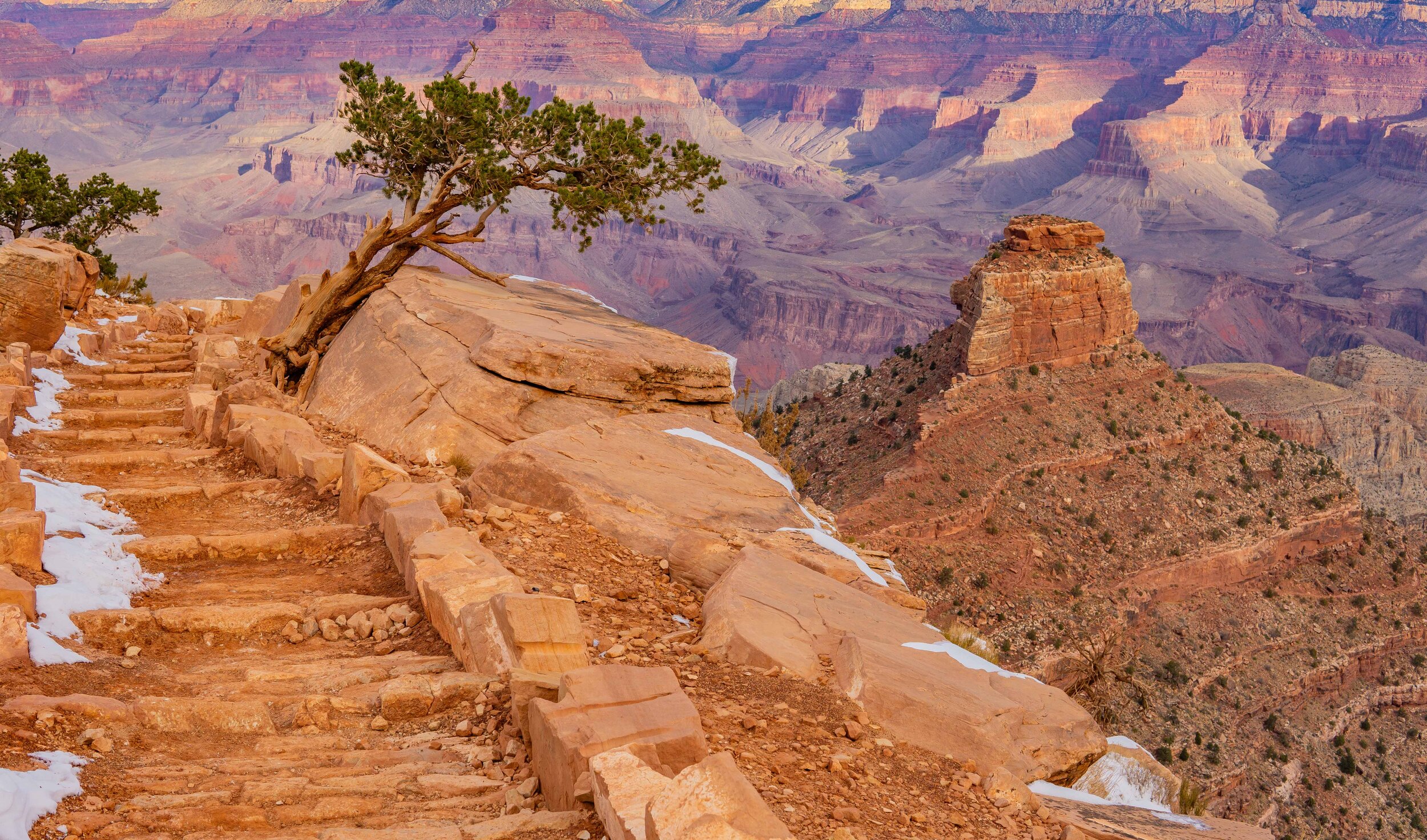
The Hike
I made sure to start this hike at sunrise to allow myself the late morning/early afternoon to hike back up. At sunrise, there were about 5 different groups of people, but mostly backpackers (based on their pack size). I ended up chatting with a few of the groups and they were all headed down to Indian Garden at the bottom of the Grand Canyon.

The first section of the trail was very icy and slick, luckily I brought my YakTrax’s with me again which made all the difference. I saw the same slipping and sliding as I saw on the Bright Angel Trail the day prior, basically, you’re going to want some sort of traction device in the winter (after a recent storm).


The ice lessened over time on the trail as the shade lessened. That being said, the sun hadn’t quite made it’s way out for the day with some overcast clouds lingering. I love a cloudy day hike because it makes for beautiful lighting.


I made it to the first popular turn around spot, Ooh Aah Point. You can probably figure out why it’s called that with it’s drastic, beautiful views of the Grand Canyon. I noticed on my way back up (later in the day) that this was the most popular turn around point of the trail.


My favorite trail view of the trip

Last bits of icy trail before reaching Cedar Ridge

Cedar Ridge
Next on the turnaround points was Cedar Ridge, another beautiful spot and it even had a restroom. It made for the perfect first stop on my hike, where I ate some snacks, took off another layer and then continued down the trail.


By this point in the trail, the sun had finally broke through the clouds and the temperatures were warming up. I was down to just my t-shirt and leggings even though I had started with many layers at the trailhead. The difference in temperatures was extreme and could be crucial in the summer. One of the groups I chatted with had said they frequented the Grand Canyon a lot and this trail has seen many, many dehydrated and overheated hikers. I could see how the heat could sneak up on you if you didn’t have the proper layers and proper amount of water.


By mid-morning, I made to Skeleton Point and spent a good amount of time chatting with the backpacking group that was around me most of the trail. Michael, Lauren, Abby, and a few others (sorry I have terrible memory!) were making their way down to the Indian Garden and they’d done it quite a few times before. They always meet back up every year or so to do the trip, even though they lived all over. I had a blast chatting with them and had a few more snacks before making my way back up the trail.
The trail was much more crowded on the way back up but it made for a good excuse to stop every once and while, catch my breath, hydrate and just take my time up the Canyon. This trail was my favorite and I already have plans to go back this summer, I hope you got some enjoyment out of this trip report and/or my video, Happy Trails!
VIDEO OF MY ADVENTURE
PIN THIS for later!


Thanks for reading my latest adventure!

Tiare Kirkland
Hi! My name is Tiare, but you can just call me ‘T’. I’m a California based hiker and I spend most of my free time taking photos and videos of some of my favorite hikes. You can usually find me ‘Out Hiking’ in the Sierra Nevada mountain range or road-tripping to new areas. Read more about me here and follow along with my adventures by subscribing below!